The Drone Pilot
Resource Hub for
FAA Airspace & Rules.

Plain-English guides to B4UFLY, LAANC, Part 107, and everything in
between — written by the team behind AutoPylot, the FAA-approved
planning app trusted by 400,000+ pilots.

FAA-approved B4UFLY & LAANC provider

4.9★ from 8,000+ reviews

Updated for June 2026 FAA rules

START HERE · 0 TO LEGAL IN 40 MINUTES

New to drones? Follow the path.

We’ll guide you from never-touched-a-drone to a fully legal first flight. Simply follow the steps, and you’ll be ready in no time!

AIRSPACE 101 · KNOW BEFORE YOU FLY

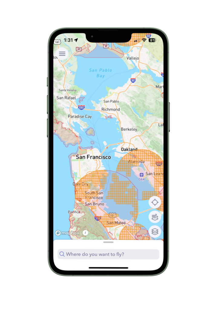
The three kinds of airspace

Every spot in the U.S. falls into one of three buckets. Here’s what each means — and how AutoPylot shows it on the map.
CLASS G Green · Clear to fly

Uncontrolled airspace (Class G)

Most rural and suburban land sits in Class G — the FAA doesn’t require authorization to fly here. You still follow the standard recreational and Part 107 rules.

  • No authorization neededYou can launch without LAANC or ATC approval. B4UFLY shows this area green.
  • 400 ft AGL ceilingStay at or below 400 feet above ground level unless flying within 400 ft of a structure.
  • Visual line of sightKeep the drone within your own line of sight at all times — day operations unless waived.
  • Still check NOTAMs & TFRsTemporary restrictions can appear anywhere. A quick check before launch is always required.
Read the full uncontrolled airspace guide →
CLASS B–E Amber · LAANC required

Controlled airspace (Class B, C, D, E)

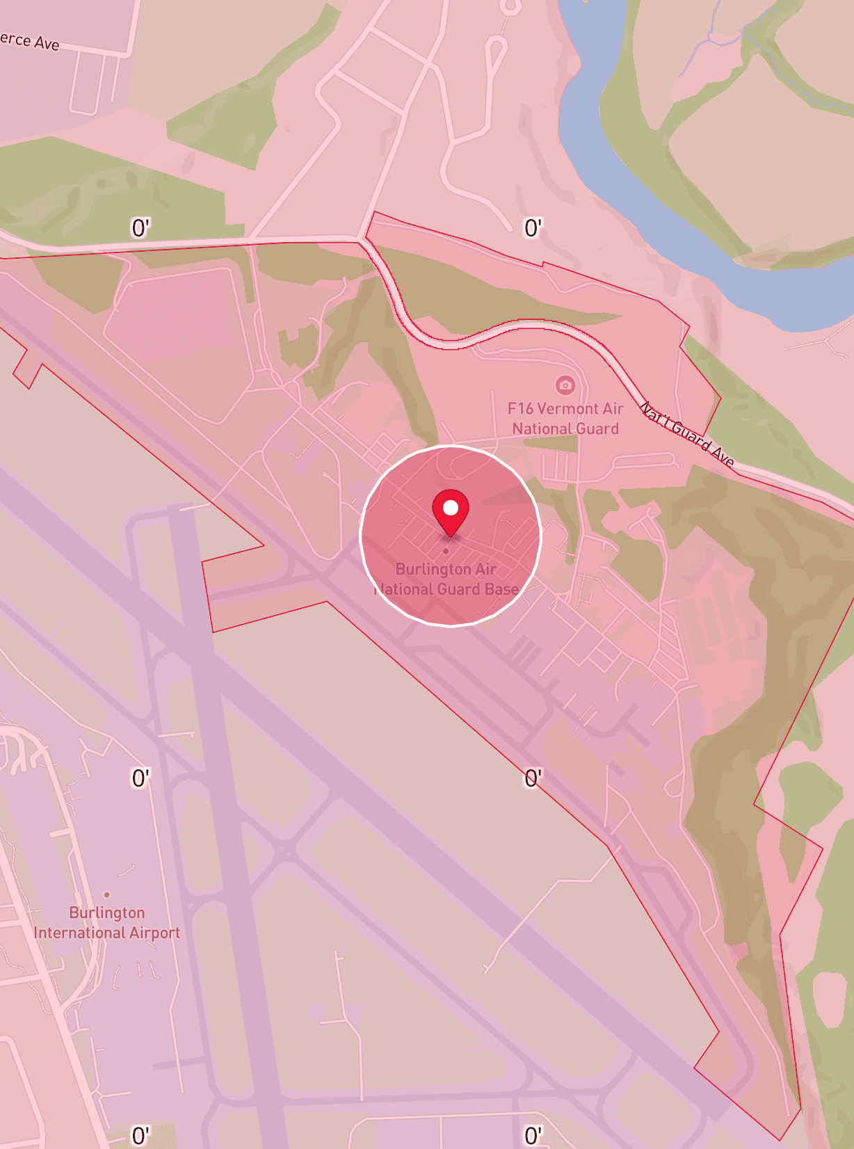
Airspace around airports is controlled. To fly here you need authorization — granted near-instantly through LAANC at or below the posted grid ceiling.

  • LAANC authorization requiredRequest through an FAA-approved provider like AutoPylot. Approval is usually instant.
  • Altitude caps by gridUAS Facility Maps set a maximum altitude for each grid square — often 0, 50, 100, or 400 ft.
  • 0 ft grids need coordinationA 0 ft ceiling means no instant approval — you must request further coordination from ATC.
  • Authorization is per-flightEach operation needs its own authorization tied to a time window and location.
Read the full controlled airspace guide →
RESTRICTED Red · Do not fly

Restricted & prohibited airspace

Some airspace is completely off-limits to drones — national parks, military installations, TFRs around stadiums and emergencies, and Washington D.C. Flight here can result in fines, criminal charges, or drone seizure.

  • No authorization availableUnlike controlled airspace, there is no LAANC option here. Flight is prohibited without a special waiver.
  • National parks are federal no-fly zonesAll 400+ NPS-managed sites ban drone operations under 36 CFR 1.5.
  • TFRs change dailyStadium events, presidential travel, wildfires, and emergencies trigger temporary no-fly zones. Always check before you fly.
  • Penalties are severeFines up to $75,000+, criminal prosecution, and FAA enforcement action. B4UFLY shows these zones in red.
Read the full restricted airspace guide →
📱 HOW IT LOOKS IN THE AUTOPYLOT APP
AutoPylot B4UFLY map showing Class G uncontrolled airspace — clear to fly AutoPylot LAANC map showing controlled airspace with altitude grid caps AutoPylot map showing restricted airspace near military base and airport
GREEN · CLEAR TO FLY
Class G airspace
AutoPylot shades this green — clear to launch.
AMBER · LAANC REQUIRED
Class B–E airspace
AutoPylot shades this amber and offers an instant LAANC request.
RED · NO FLY
Restricted airspace
AutoPylot shades this red — flight is prohibited without special waiver.
EDITOR’S PICKS

What pilots are reading this week.

WHY TRUST THIS HUB

Built by an FAA-approved provider.

AutoPylot is one of the largest FAA-approved providers of both B4UFLY airspace information and LAANC authorizations.

0K+
Missions created
by pilots
0K+
App downloads
across iOS & Android
0
App Store rating
across iOS & Android

FAA-APPROVED B4UFLY SERVICE PROVIDER FAA-APPROVED LAANC USS SKYWATCH.AI INSURANCE PARTNER NPS DATA INTEGRATED
GLOSSARY

Speak fluent drone

The drone operator alphabet, decoded. Click any letter to find and learn the terms.
AGL
Above Ground Level — altitude measured from the surface directly below, not sea level. Recreational and Part 107 drones must stay at or below 400 ft AGL.
B4UFLY
The FAA's official "Before You Fly" safety standard that shows airspace status in green, yellow, and red so pilots know where it's safe to operate. AutoPylot is an FAA-approved B4UFLY provider.
Controlled Airspace
Airspace classes B, C, D, and E where air traffic control services are provided. Drone pilots must obtain LAANC authorization before flying in controlled airspace.
Grid Ceiling
The maximum altitude approved for drone flight in a specific LAANC grid square, set by the UAS Facility Map. Common values are 0, 50, 100, 200, and 400 ft.
LAANC
Low Altitude Authorization and Notification Capability — the FAA system that gives drone pilots near-real-time approval to fly in controlled airspace. AutoPylot is an FAA-approved LAANC provider.
Part 107
The FAA regulation governing commercial drone operations. Requires passing a knowledge test to earn a Remote Pilot Certificate — required for any flight that supports a business.
Remote ID
A "digital license plate" for drones. As of 2024, most drones must broadcast their identity, location, altitude, and control station position during flight.
TFR
Temporary Flight Restriction — a short-notice no-fly area, often for sporting events, presidential movement, wildfires, or emergencies. Violations carry fines up to $75,000+.
TRUST
The Recreational UAS Safety Test — a free, online knowledge test required by the FAA for all recreational drone pilots. Educational, correctable, and valid for life.
VLOS
Visual Line of Sight — the requirement that a pilot must see their drone with unaided eyes at all times during flight. Standard rule for both recreational and Part 107 operations.
These are 10 of 60+ terms every drone pilot should know. View the full glossary →

PLAN TO FLY

You've read the guides. Now plan a flight

AutoPylot puts every airspace check, weather forecast, LAANC request, and checklist in one place — free for recreational and Part 107 pilots.

FAQS

The questions every new pilot asks.

In most cases, yes.

  • If your drone weighs more than 250 grams (0.55 lbs), it must be registered with the FAA, regardless of whether you fly recreationally or under Part 107.
  • If you fly under Part 107 (commercial operations), all drones must be registered, even if they weigh less than 250 grams.
  • If you fly recreationally and your drone weighs less than 250 grams, FAA registration is generally not required.

Keep in mind that other requirements, such as Remote ID, may still apply depending on your drone and how you operate it.

B4UFLY helps you understand whether it is safe and legal to fly where you are. It displays the airspace status of a location using color-coded advisories, such as green, yellow, and red zones.

LAANC (Low Altitude Authorization and Notification Capability) is the FAA’s authorization system that allows drone pilots to obtain approval to fly in certain controlled airspace. If you’re flying in a yellow-controlled airspace zone, LAANC can often provide near real-time authorization to fly at or below the published altitude limits.

Think of it this way: B4UFLY tells you the rules, and LAANC helps you get the authorization needed to fly when approval is required.

AutoPylot is an FAA-approved provider for both B4UFLY and LAANC, allowing you to check airspace restrictions, understand where you can fly, and request LAANC authorizations—all from a single app.

In most cases, no. Launching, landing, or operating a drone is generally prohibited within lands and waters managed by the U.S. National Park Service (NPS).

Some parks may issue special permits or allow drone operations for specific purposes, such as scientific research, search and rescue, or other authorized activities, but these exceptions are rare.

Before flying, always check the area for National Park boundaries and any applicable restrictions. AutoPylot displays National Park Service areas and other airspace advisories to help you determine whether a location is legal to fly.

In most cases, yes.

If you are flying a drone for work, business, compensation, or in furtherance of a business, you generally need an FAA Part 107 Remote Pilot Certificate.

Examples include:

  • Real estate photography
  • Construction site documentation
  • Roof inspections
  • Mapping and surveying
  • Content creation for a business
  • Any flight where you are being paid or providing a service

If you fly strictly for recreational purposes, a Part 107 certificate is not required.

Keep in mind that the FAA looks at the purpose of the flight, not just whether money changes hands. If the flight supports a business or commercial activity, Part 107 is typically required.

LAANC is typically free. While some FAA-approved LAANC providers may charge for access to LAANC services, many providers—including AutoPylot—offer LAANC authorizations and airspace information at no cost.

FAA-approved providers are held to a higher standard than a typical drone airspace app.

To maintain FAA approval, providers undergo regular testing and validation to ensure they are accurately displaying FAA data and meeting the FAA’s requirements for airspace awareness. The FAA also defines what information must be displayed, helping ensure pilots see more than just controlled airspace.

In addition to UAS Facility Maps (UASFM), FAA-approved providers are required to display important advisories and restrictions such as:

  • Temporary Flight Restrictions (TFRs)
  • Stadium advisories
  • Military Training Routes (MTRs)
  • National Park Service areas
  • Special use airspace and other FAA-provided advisories

While some drone apps may display portions of this information, there is often no FAA oversight or auditing process to verify that all required data sources are being ingested correctly or that all relevant restrictions are being shown to pilots.

Additionally, FAA-approved LAANC providers allow operators to request authorization to fly in controlled airspace directly through the app. This is something that most drone airspace apps—and even the FAA’s UAS Facility Maps themselves—cannot do.

AutoPylot is an FAA-approved provider for both B4UFLY and LAANC, giving pilots access to official FAA airspace information and the ability to request LAANC authorizations from a single app.