Airspace Basics for Drone Pilots
Getting the airspace basics right is the first thing every drone pilot has to do — it’s what stands between a legal flight and an accidental FAA violation. Whether you’re flying recreationally or for paid commercial work, the question before every takeoff is the same: is this spot clear to fly, or do you need authorization first? This guide explains how U.S. airspace works for drones in plain English — no pilot’s license or chart-reading experience required — so you can answer that question with confidence anywhere you fly.
Quick answer
Understanding drone airspace basics is the single most important thing you need before flying. U.S. airspace is divided into classes that determine where you can fly freely and where you need FAA authorization. Most recreational drone flights take place in Class G (uncontrolled) airspace, where no authorization is required. Near airports, you enter controlled airspace (Classes B, C, D, E) and must request LAANC before flying. AutoPylot shows your drone airspace status instantly — green, amber, or red.
Why airspace matters for drones
Even though your drone never climbs anywhere near a passenger jet’s cruising altitude, you’re still sharing the national airspace system with crewed aircraft — especially near airports, where planes and helicopters fly low. Understanding airspace is key to staying legal, staying safe, and avoiding flying somewhere you shouldn’t.
The good news: as a drone pilot, you don’t need to memorize all of aviation. You mostly need to answer one question before every flight: “Is this spot controlled or uncontrolled, and do I need authorization?”
The 400-foot rule
Drones are generally limited to 400 feet above ground level (AGL). That keeps you well below most crewed traffic — but it does not exempt you from airspace rules near airports.
Controlled vs. uncontrolled airspace
Every piece of airspace is either controlled or uncontrolled. The difference comes down to whether Air Traffic Control (ATC) manages the traffic there.
Uncontrolled airspace (Class G) is everywhere else. ATC has no authority, and drones can generally fly without prior authorization — though all the other rules (400 ft, line of sight, no TFRs) still apply
Controlled airspace (Classes B, C, D, and E) surrounds airports and busy corridors. ATC has authority here. For drones, flying in controlled airspace at the surface requires LAANC authorization.
“Uncontrolled” doesn’t mean “no rules”
Class G is the most permissive airspace, but you still must follow FAA rules, stay clear of TFRs and restricted areas, and keep your drone in sight at all times.
The airspace classes, B through G
There are six classes (A–G, skipping F, which the U.S. doesn’t use). Class A is high-altitude airspace for airliners — drones will never touch it. The ones that matter to you are B through G:
The drone-pilot shortcut
You rarely need to know which controlled class you’re in. What matters is: controlled = needs LAANC, uncontrolled (Class G) = usually clear. An app like AutoPylot reads this for you automatically.
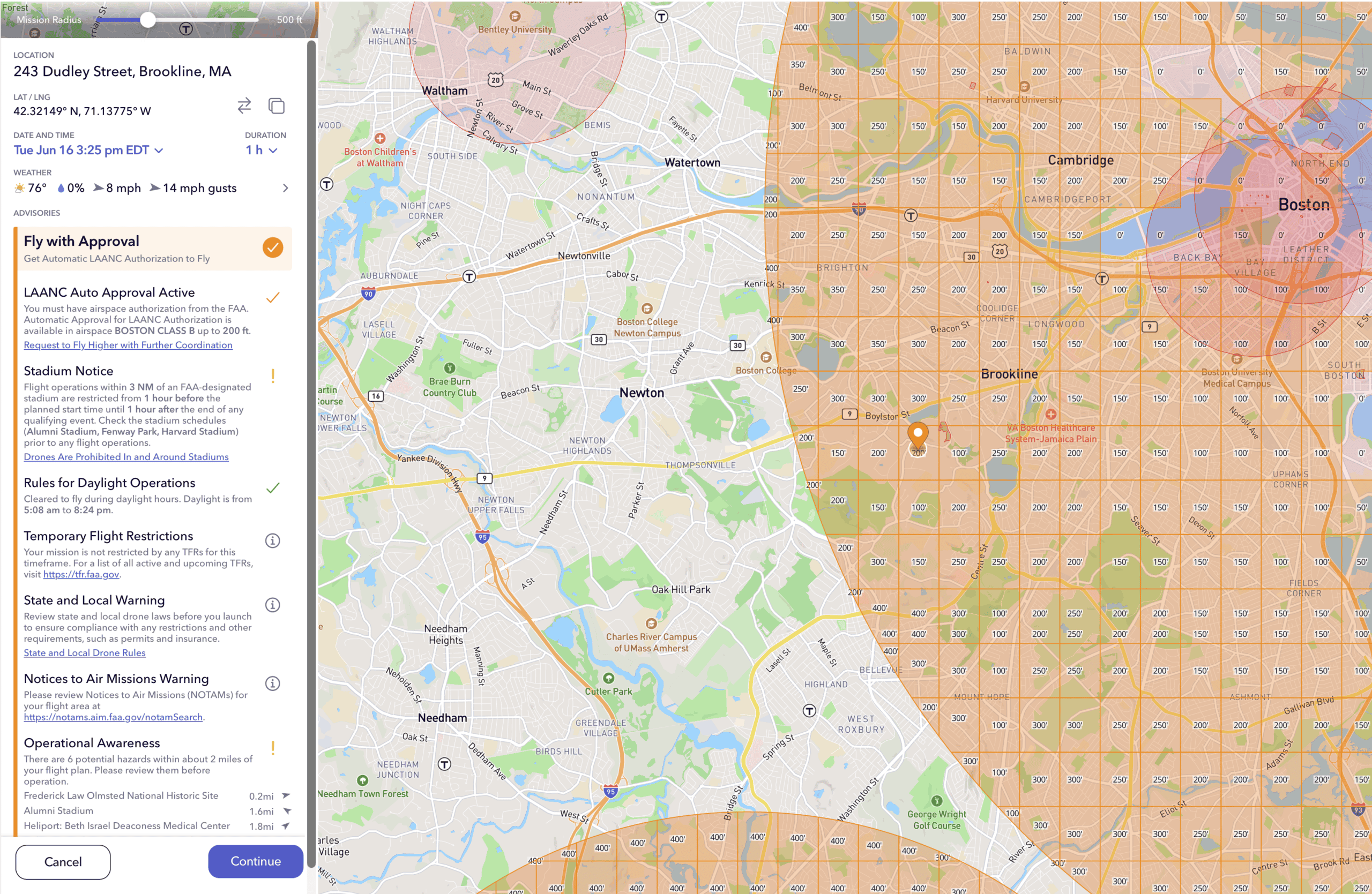
Reading a sectional chart
A sectional chart is the official aeronautical map of U.S. airspace. The colored lines and numbers tell you exactly which class you’re in and how high it goes. The key markings:
- Solid blue lines — Class B airspace boundaries
- Solid magenta lines — Class C airspace
- Dashed blue lines — Class D airspace (towered)
- Faded magenta shading — Class E starting at 700 ft AGL
- Magenta dashed ring — Class E reaching down to the surface
- Altitude blocks (e.g. 100/SFC) — ceiling over floor, in hundreds of feet

You don’t have to interpret these by hand. Apps that read UAS Facility Maps (UASFM) — the FAA’s drone-specific altitude grids — translate the chart into simple “you can fly up to X feet here” answers.
Special-use airspace & TFRs
Beyond the lettered classes, some areas have extra rules you must respect:
| Area type | What it means for drones |
|---|---|
| Prohibited areas | No flight, ever. Think national landmarks and sensitive sites. |
| Restricted areas | Hazardous activity (e.g. military). Off-limits when active. |
| TFRs | Temporary “pop-up” no-fly zones for events, VIP movement, wildfires, and disasters. Check before every flight. |
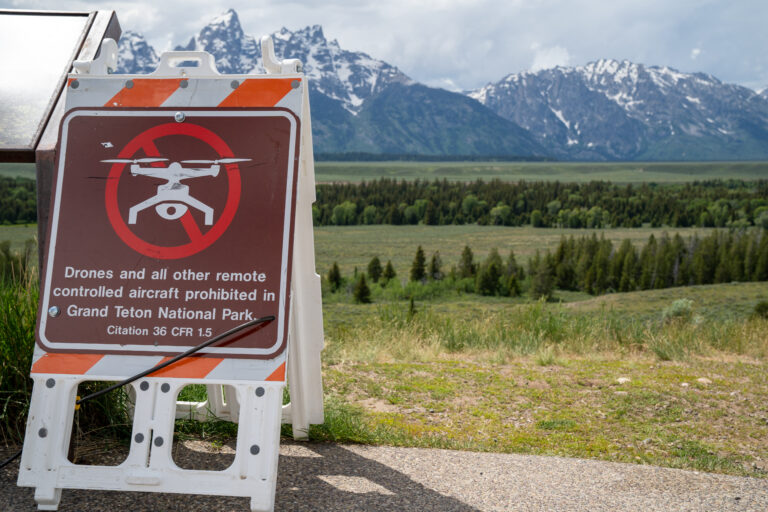
| National parks | The Park Service prohibits launching or landing within most park boundaries. |
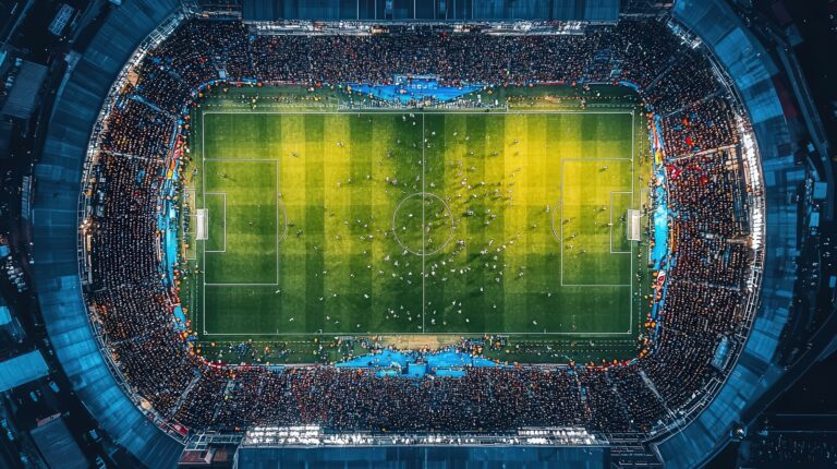
| Stadiums | Blanket TFR within 3 nautical miles 1 hour before and 1 hour after major sporting events. |
TFRs are the #1 trap
TFRs pop up on short notice and aren’t printed on charts — legal yesterday, no-fly today. AutoPylot doesn’t just display them; it monitors your authorized missions and alerts you if a new TFR overlaps with them before you launch.
When do you need LAANC?
Here’s the bottom line for almost every drone flight:
- Check your location. Is it controlled or uncontrolled airspace?
- Uncontrolled (Class G)? You’re generally clear to fly — just confirm there are no TFRs or restricted areas. Make it a habit to also always check Notams.
- Controlled (B/C/D/surface E)? You need LAANC authorization before flying, and it’s often granted in seconds with platforms like AutoPylot.
- Above the grid’s max altitude? You’ll need to request further coordination with the FAA, which takes longer.
Skip the chart-reading — check your spot instantly
AutoPylot reads the airspace, UAS Facility Maps, and live TFRs for you, then files LAANC in seconds. Free for recreational, commercial, and government pilots.
Airspace Basics FAQ
Controlled airspace (Classes B, C, D, E) is where Air Traffic Control manages traffic — typically around airports. Uncontrolled airspace (Class G) is everywhere else. For drones, controlled airspace at the surface requires LAANC authorization, while Class G generally doesn’t.
Yes, but only with authorization. Class B surrounds the busiest airports, and you must obtain LAANC approval before flying there. The approved altitude is often very low (sometimes 0 feet in the innermost rings), so always check the UAS Facility Map for your exact location.
Yes. Even at a familiar spot, Temporary Flight Restrictions can be imposed with little notice for events, VIP movements, or emergencies. A 30-second check before each flight protects you from accidentally entering a no-fly zone.
Drones are generally limited to 400 feet above ground level (AGL) in uncontrolled airspace. In controlled airspace, your maximum altitude is set by the UAS Facility Map grid for that location — which may be lower than 400 feet, or require further coordination above the grid value.